Thursday, May 28, 2026 |Navi Mumbai
--:-- | --°C | AQI --
If it's not on Unbox Daily HQ, it's not a Launch. Every product, policy and brand launch in India. One hub. What's new?
IITM and Andhra University’s C-ART facility uses 3D-printed sensors to improve cyclone warnings on the east coast.

The Essentials

The Pulse
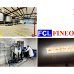
This is not just another government weather station; it is a precision laboratory for the east coast. While most weather data in India comes from generic sensors, the Coastal Atmospheric Research Testbed (C-ART) looks at the minute physics of rain to understand why certain storms turn severe. The facility began operations on 1 May 2026 and marks a shift towards using high-resolution local data rather than broad estimates.
The facility uses 3D-printed automatic weather stations and eddy covariance towers to track turbulence and wind information. By measuring drop size distributions and rain-microphysics, scientists can finally see the internal mechanics of a monsoon thundershower. This matters because it allows for more accurate numerical models that predict where a cyclone might actually make landfall.
The Coastal Atmospheric Research Testbed improves Indian weather forecasting by providing high-resolution data on raindrop size and shape to refine numerical weather models.
For those living in coastal cities like Visakhapatnam or Chennai, this is the infrastructure that determines if you get a weather alert two hours early or two days early. It is a long-term collaboration between the Ministry of Earth Sciences and Andhra University to make sure the data used by our meteorologists matches the reality on the ground.
ⓘ Sponsored: Unbox Daily HQ earns a commission if you buy through these links, at no extra cost to you. Prices shown are subject to change, and the actual price on Amazon at the time of purchase may vary from what is displayed here.
The Snapshot
| Feature | Detail |
| Facility Name | Coastal Atmospheric Research Testbed (C-ART) |
| Location | Andhra University Campus, Visakhapatnam |
| Lead Agency | Indian Institute of Tropical Meteorology (IITM) |
| Parent Ministry | Ministry of Earth Sciences (MoES) |
| Key Tech | 3D-PAWS, 2D Video Disdrometer, Eddy Covariance Tower |
| Future Tech | Polarimetric Doppler Radars, Scanning Wind Lidar |
| Primary Goal | Improving cyclone and extreme weather predictions |
| India Price | Price not confirmed (National research facility) |
| Status | Operational as of 1 May 2026 |
The Big Picture
This facility is part of the larger Mission Mausam initiative, which aims to fill the gaps in India’s observational network. For years, Indian weather forecasting has relied on satellite data and a limited number of ground stations. By placing a testbed directly on the coast, IITM is tackling the specific challenge of maritime-to-land weather transitions. This puts India’s coastal monitoring on par with similar high-density networks globally, focusing on local nuances that regional models often miss in the Bay of Bengal.
The Inside Intel
Meteorologists at the site are using 3D-printed weather stations to gather data. This choice is deliberate; 3D-PAWS are significantly cheaper to produce and easier to maintain than traditional metal-housed sensors. If a sensor is damaged during a severe cyclone, the team can replace it quickly by printing a new one on-site, ensuring that the stream of data never breaks when it is needed most.
The UDHQ. Take
This is a necessary upgrade for anyone whose life or business is dictated by the Indian monsoon. At Unbox Daily HQ., we see this as a pivot from reactive disaster management to proactive science. While you cannot buy a C-ART station for your home, the data it produces will eventually feed into the weather apps and government alerts you use every day.
The move to 3D-printed hardware is particularly clever, showing that the Ministry of Earth Sciences is prioritising speed and scalability over traditional, slower procurement cycles. It is the kind of practical engineering that makes our national weather grid more resilient. If you live in a coastal zone, this facility is essentially the new silent guardian of your safety.
Best for: Residents of coastal India who require more reliable and hyper-local weather alerts during cyclone season.
Who Is This For: Perfect for 28 to 55-year-old professionals and homeowners in coastal cities who need precise data for disaster preparedness.
The Checkout
Indian Institute of Tropical Meteorology
The Source
Ministry of Earth Sciences | PIB.GOV.
The Coastal Atmospheric Research Testbed was inaugurated on 1 May 2026 and is already active at the Andhra University campus. As a national research site, it does not have a consumer price tag but works behind the scenes to power government weather alerts.
Most stations provide broad data, but this facility uses specialised 3D-printed sensors and video disdrometers to measure individual raindrops. This level of detail helps meteorologists build more accurate models to predict exactly how a cyclone will behave when it hits the coast.
The project is a major win for anyone living in storm-prone regions who needs reliable alerts to prepare for heavy rainfall. By making monsoon predictions more precise, it gives residents and disaster teams the clear information they need to stay safe during extreme weather.