Thursday, May 28, 2026 |Navi Mumbai
--:-- | --°C | AQI --
If it's not on Unbox Daily HQ, it's not a Launch. Every product, policy and brand launch in India. One hub. What's new?
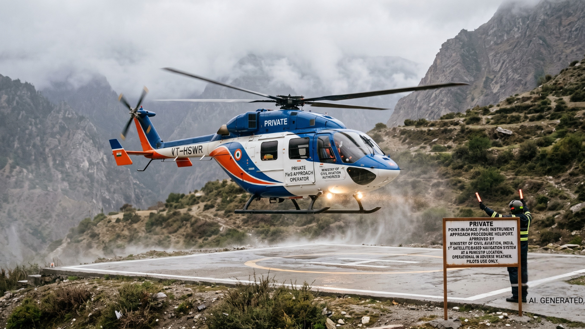
The new PinS procedure at Undavalli Heliport uses satellite navigation to guide helicopters safely through bad weather.
The Essentials
The Pulse
India’s first Private Point-in-Space (PinS) Instrument Approach Procedure allows helicopters to land precisely using satellite navigation instead of relying on ground-based radio aids. Approved for the Undavalli Heliport in Andhra Pradesh, this shift removes a major historical limitation for domestic aviation.
Helicopters traditionally require clear visibility or expensive ground infrastructure to land safely.
What is a Point-in-Space approach procedure?
It is a satellite-guided flight path that lets a pilot navigate through clouds and bad weather directly to a specific coordinate in the sky near the helipad, before making a short visual descent.
ⓘ Sponsored: Unbox Daily HQ earns a commission if you buy through these links, at no extra cost to you. Prices shown are subject to change, and the actual price on Amazon at the time of purchase may vary from what is displayed here.
This development directly alters how emergency medical services and disaster relief operations function. By eliminating the need for complex ground signals, helicopters maintain all-weather accessibility to remote areas. The Ministry of Civil Aviation built this to global standards, aiming to create a template that reduces weather-related disruptions for tourism, offshore activities, and regional connectivity flights nationwide.
The Snapshot
| Detail | Specification |
| Project | First Private Point-in-Space (PinS) Procedure |
| Location | Undavalli Heliport, Andhra Pradesh |
| Technology | Satellite-based navigation |
| Developed By | Airports Authority of India (AAI) |
| Approved By | Directorate General of Civil Aviation (DGCA) |
| Global Standard | International Civil Aviation Organization (ICAO) |
| Key Applications | Emergency services, disaster relief, tourism, offshore |
The Big Picture
Indian aviation relies heavily on expanding regional connectivity, but helicopter operations frequently stall during adverse weather or in difficult mountainous terrain. Upgrading to Performance-Based Navigation aligns domestic infrastructure with global practices. Moving away from ground-based aids toward satellite networks allows operators to fly under Instrument Flight Rules into previously inaccessible zones. This move creates a standard template that can be replicated at remote helipads nationwide, stabilising operations for everything from corporate transport to critical medical evacuations across challenging Indian landscapes.
The India Prospective
For the average Indian traveller, this directly translates to fewer cancelled flights during pilgrimage seasons and corporate trips. The government just completed the first phase of this year’s Char Dham helicopter operations without incident using similar upgraded technological infrastructure. As these satellite-guided procedures expand, accessing remote tourist destinations or securing emergency medical evacuation during monsoon months becomes significantly more reliable.
The Inside Intel
While this specific helicopter procedure marks a major domestic first, it follows closely on the heels of another quiet aviation milestone. Just last week, the Ministry of Civil Aviation successfully demonstrated the country’s first indigenous GAGAN-based precision approach using a commercial aircraft. Both milestones confirm a rapid, deliberate shift towards relying heavily on India’s own satellite navigation networks rather than imported systems.
The Unboxed Truth
Unbox Daily HQ considers this a critical upgrade for Indian aviation that finally treats helicopter travel as a reliable utility rather than a fair-weather luxury. While commercial airlines have used advanced navigation for years, extending this satellite capability to helicopters means safer, more consistent access to remote areas. The real value lies in standardising this approach nationwide, turning dangerous monsoon evacuations and delayed pilgrimage flights into predictable, routine operations.
Best for: Frequent corporate travellers and regional tourists who rely on consistent flight schedules.
Who Is This For: Perfect for 30 to 60-year-old professionals and pilgrims in India who require safe, weather-independent helicopter access to remote or high-altitude destinations.
The Checkout
The Source
Ministry of Civil Aviation | PIB.GOV
The Query
The first Private Point-in-Space (PinS) Instrument Approach Procedure is available at the Undavalli Heliport in Andhra Pradesh. Developed by the Airports Authority of India, this satellite-based system has received official approval from the Directorate General of Civil Aviation. It allows helicopters to conduct safe, precise instrument approaches without conventional ground infrastructure.
A PinS procedure utilises advanced satellite navigation to guide helicopters safely through clouds and bad weather instead of relying on ground-based radio aids. Traditional infrastructure requires clear visibility or complex ground installations to operate safely. This system allows pilots to navigate precisely to a specific coordinate before making a short visual descent.
Unbox Daily HQ considers this infrastructure essential for frequent corporate travellers, regional tourists, and pilgrims who require reliable, weather-independent flight schedules. The system provides immense practical value by turning unpredictable bad-weather flights into predictable, routine operations. It eliminates the delays and safety anxieties typically associated with monsoon or high-altitude travel.